 Eigerpedia
Eiger for Android™ is the Eigerpedia!
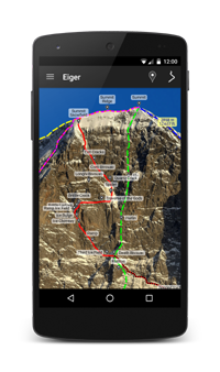
Routes and points displayed on image of the Eiger North Face (Eigerwand or Eiger Nordwand).
You can zoom in for a closer look and zoom out for an overall view.
Routes and points are accurately positioned. They can be turned on and off as sets or individually.
You can also display elevation for any location on the mountain.
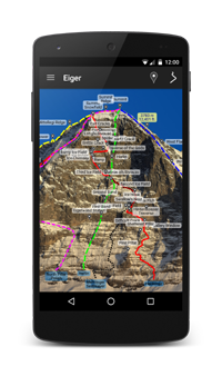
11 Eiger climbing routes
- Heckmair Route (1938 Route)
- John Harlin Direct Route
- Lauper Route (Northeast Face Route)
- Mehringer/Sedlmayer (1936 Route)
- Magic Mushroom
- Metanoia
- Mittellegi Ridge
- North Pillar Messner
- North Pillar Polish
- Paciencia
- West Flank
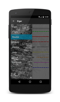
Style and colors for routes can be easily customized.
40+ points of interest
- Brittle Crack
- Brittle Ledges
- Corti Bivouac
- Death Bivouac
- Difficult Crack
- Eigerwand Station
- Exit Cracks
- First Ice Field
- First Pillar
- First Band
- Flatiron
- Fly
- Gallery Window (Dynamitloch) km 3.6
- Gallery Window (Stollenloch) km 3.8
- Gallery Window km 4.1
- Great Tower
- Harlin fell
- Hinterstoisser Traverse
- Ice Bulge
- Ice Chimney (Waterfall Chimney)
- Ice Hose
- Japanese Ledge
- Kanzeli (Mushroom)
- Longhi Bivouac
- Mittellegi Hut
- Mittellegi Ridge
- Northeast Face
- Quartz Crack
- Ramp
- Ramp Ice Field
- Rote Fluh
- Rotstock
- Second Ice Field
- Second Band
- Shattered Pillar
- Silver Trench
- Spider (White Spider)
- Summit
- Summit Snowfield
- Summit Ridge
- Swallow's Nest
- Third Ice Field
- Traverse of the Gods
- West Flank
- West Flank Bivouac
- West Ridge
Eigerpedia is free and there is no advertising!

Android is a trademark of Google Inc.